The following maps are based upon the posted maps at the park, as corrected by myself. No warranties are express or implied. You use these maps at your own risk.
These maps are in no way sanctioned by the Cincinnati park board.
In 2003 (As best as I can determine), new trail markers were installed in the park, mostly at places where the trail system hooks up with the streets. The markers consist of 4x4 inch posts, with markings routed into the wood and painted, color-coded trail letters. They are about 3 feet tall, and pretty nice.
The existing markers that refer to park areas (Indicated on the map by circled numbers) are a good way to figure out where you are. The E blazes cover most of the long trails, and are not very useful for navigation. There are also some unoffical blazes in the park, but I have not yet been able to determine what these reflect.
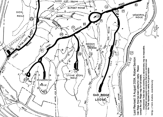
Areas 14, 15, and 16 are listed on the maps, but for all practical purposes no longer exist.
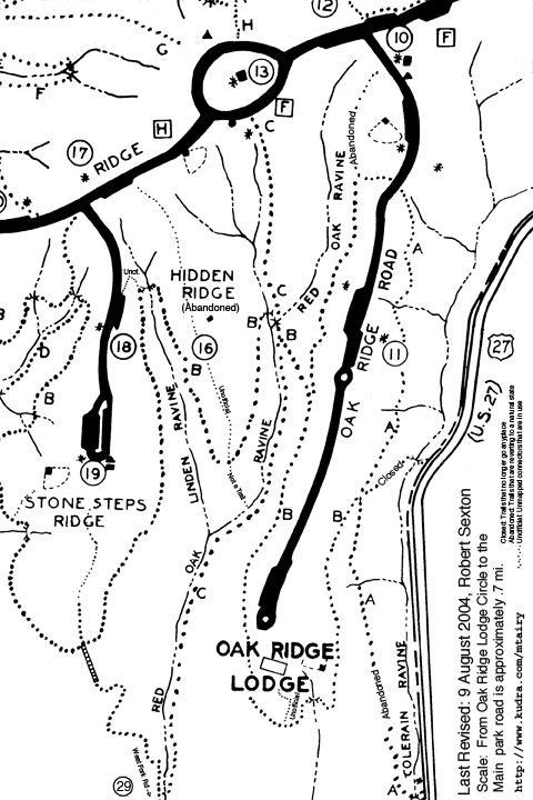
The A,B,and C trails form a good loop that encircles the Oak Ridge lodge. Start at the A post just north of area 11, and circle clockwise, picking up the B trail, Then turn right onto the C trail and exit onto the circle surrounding area 13.
Alternately, stay to right as the B trail forks on the west side of Oak Ridge road, and exit near area 10 and the baseball diamond.
The southernmost portion of the B loop is fairly rocky, and can be a little difficult for running.
The southern connector to Colerain avenue is still passable, but is suffering from erosion and many deadfalls. Its in bad shape. Traces of the northern connector still exist, but the bridge over Colerain ravine no longer exists, so the trail ends at a small cliff.
The C Trail, aka the Red Oak trail does not connect with West fork road any longer. You can bushwhack your way through a field and get to West Fork, but there is no real path. Oddly enough, there is a new trail marker at the southernmost point on the trail. Its a good workout up the stairs to Stonesteps ridge.
This map has been updated to reflect the changes in the Sunset Ridge area north of area 13. The posted maps are misleading, due to the relocation of the 'G' Trail. There is a trail post for the H trail. The G trailhead is unmarked. It begins right behind the radio antenna to the left of the bathrooms.
The C Trail, aka the Red Oak trail does not connect with West Fork road any longer. You can bushwhack your way through a field and get to West Fork road, but there is no real path. Oddly enough, there is a new trail marker at the southernmost point on the trail. Its a good workout up the stairs to Stone Steps ridge.
As best as I can tell, the G trail was re-routed to travel along the ridge through what was once area 14 towards what was once area 15.
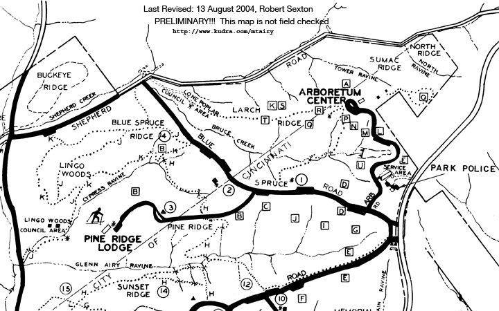
This map is currently under revision. The trails in the Lingo Woods - Blue Sprice Ridge area are suspect. I'll be making GPS traces soon.
Questions? Contact Robert Sexton: robert, at kudra.com